Affordable housing, plans for the Truckee River, selling the CAC properties, and more
By Dr. Alicia Barber
Reno City Council meets on Wednesday, September 25, with the agenda and links to supporting materials posted here. It’s a packed meeting, so be sure to scan through it for items of interest to you. You can find the rest of the City’s weekly schedule here.
Today I’ll highlight some development-related items on the Council agenda, including affordable housing fee reductions; several items related to the Truckee River and its frontage; and sales of City-owned land including the former CAC properties on Record Street and a parcel on East 4th Street. After that I have a few updates and the latest in local development news. So let’s dive in.
Support for affordable housing
At a time when the median price of homes in Reno has just soared to its second highest number ever ($650,000) it’s nice to see so many affordable housing projects underway. Reno City Council is supporting some of those projects in a few ways:
- Item B.23 – This is a resolution to be provided to the Nevada Department of Business and Industry, supporting the 402-unit “Skyline Flats” affordable housing development on Dandini Blvd. This is not direct financial support but will enable the state to issue tax-exempt bonds, as you can read in the Staff Report here.
- Item C.2 – Affordable housing fee reduction of up to $1,465,059 in sewer connection fees for the Stoker by Vintage Apartments at 500 Stoker Avenue (below). You’ll find the Staff Report here and a post from Downtown Makeover here.

- Item C.3 – Affordable housing fee reduction of up to $21,120 in building permit fees and up to $451,186 in sewer connection fees for the Line Drive Apartments at 700 Line Drive. This is a 50-unit project intended to serve “veterans, persons experiencing homelessness or at risk of homelessness, and extremely and very low-income adults with physical and/or cognitive disabilities.” That Staff Report is here and you can find a Downtown Makeover post here that includes a link to a prior Washoe County presentation about the project.
Creation of a linear Truckee River Park?
Two agenda items pertain to the future of the Truckee River and adjacent land.
First, Item D.1 is a resolution to designate all City of Reno owned and/or controlled property located adjacent to the Truckee River, between Booth Street and South Virginia Street, as a City of Reno park pursuant to RMC Sec 8.23.010.
The Staff Report offers these reasons for the action:
- Regulations changing along the path can cause confusion for residents and visitors as there is a presumption that the regulations are consistent throughout;
- Vehicles allowed in parks and along paths differ from what is allowed along what is considered sidewalks;
- Park regulations prohibit blocking paths while keeping the paths clear for transportation whereas a sidewalk can be blocked provided it remain accessible (at least 30 inches);
- Maintenance responsibility would be more clearly defined and efficient with consistent designation;
- Increased efficacy of Park/River Ranger position through the expansion of park boundaries;
I appreciate this list, but I’m not sure it effectively conveys the tangible implications of such a designation. For instance, what specific types of vehicles are allowed on sidewalks that would no longer be allowed were these spaces to be classified as parks? And how would the differing regulations about “blocking paths” impact the people who use them? Do these prohibitions refer to objects, people, or both? You can find the regulations governing city parks in Municipal Code 8.23 here, but it would be nice not to have to figure all of that out for ourselves.

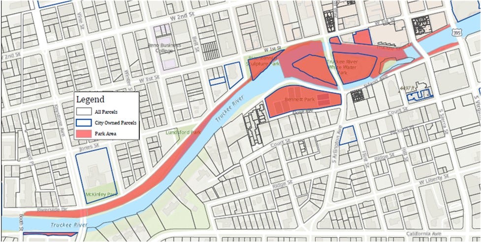
I was also confused about what specific areas would be impacted. A map is included with the Resolution, but it doesn’t clearly depict which areas would shift from non-park to park. I wrote to Parks Planner Karina Mercier on Friday and got this response:
“The change is to ensure that there is a continuous connection along the river. But as you have observed, most of the areas are already designated as City Parks so there wouldn’t be a significant change, the main difference would be the addition of APN 011-132-06 (the parcel south of the river by Booth street), and the rights of way pathways such as Truckee River Lane, which is the area east of West Street Plaza and west of Virginia Street, already controlled by the City.”
She also sent me a new map that she said she’d be showing at City Council. It’s titled “Truckee River Park,” which would ostensibly comprise everything marked in red.
This designation seems like a big deal to me, and something that deserves substantial discussion to fully flesh out its potential implications for everyone who uses these spaces now or will in the future, as well as its relationship to the Truckee River Vision Plan, which proposes the formation of a Truckee River Park District.
The Truckee River Vision Plan
Item D.3, the presentation, discussion, and potential approval of the Truckee River Vision Plan, was initially scheduled for discussion on August 28 but has been delayed a few times. The Staff Report recommends that Council approve the plan “and direct staff to pursue project opportunities outlined in the implementation plan and bring identified projects forward when action can be taken.”
You can view the 67-slide presentation accompanying the plan here and the final detailed 223-page Truckee River Vision Plan itself here.
As I mentioned above, one of this plan’s central recommendations is to partner with Washoe County and the City of Sparks to create a Truckee River Park District to help generate funds. That’s discussed in detail beginning on p. 136 of the plan and is just one of the “Next Steps” listed at the end of the presentation. Here are the others:
- Complete ARPA Funded Projects (those are listed in the Staff Report)
- Create a Service Plan for the Parks District
- Implement Overlay Zoning District (this starts on p. 67 of the plan)
- Develop Funding Plan to Complete High Priority Projects and Quick Wins
This plan is extensive, and I think most of its contents (like renderings of the various riverfront spaces) are being presented as recommendations, but it would be good to clarify what exactly Council would be approving if they approve the plan (i.e. which “project opportunities” Council would be simultaneously directing staff to pursue).
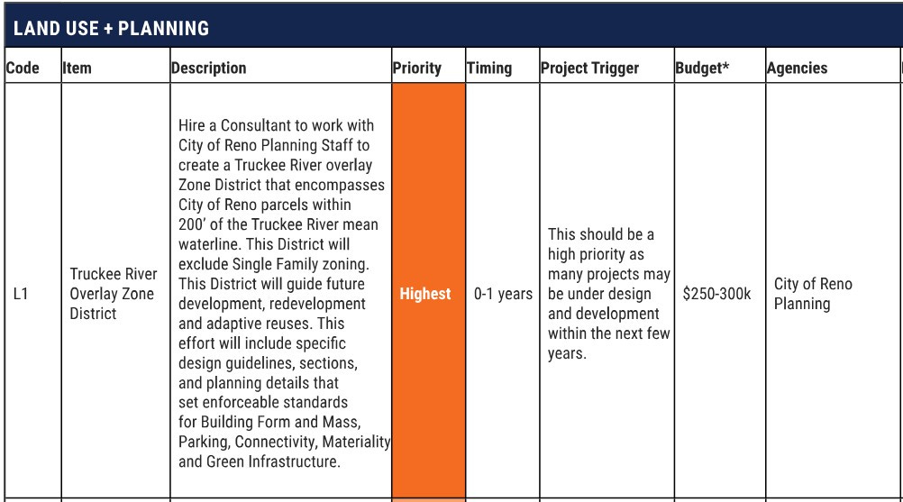
To help with that, be sure to check out pages 144-159 of the plan, where you’ll find a detailed “Implementation Matrix” that lists specific recommendations and assigns each one a priority level, timing, a “project trigger,” estimated budget, responsible agencies, and funding sources. I’ll include just one excerpt from that below.
This is a huge initiative with many parts and players, so I look forward to learning how the City will ensure that every step is community-centered as it moves forward.
Read the rest at The Barber Brief.
The Barber Brief is an independent e-newsletter and blog written by Dr. Alicia Barber on the Substack platform. It is reposted by This Is Reno with her permission.

