
Click to view a full-screen slideshow of more than 75 images. | Republished from ThePathLessBeaten.com
The trail to Gibbs Lake may be a trail you’ve never heard of before. I had never heard of it until I read the trail description in the book Exploring Eastern Sierra Canyons. This book is an excellent source for finding the hidden, off-the-beaten-path hikes along the Eastern Sierras.
Before starting this hike, we stopped at the Mono Basin National Forest Scenic Area Visitor Center for our wilderness permit (required for an overnight stay in the Ansel Adams Wilderness) and a map. The visitor center reminds me of a busy airport. But instead of flights and boarding passes, it’s hiking and permits. As we stood in line, you could hear that people were headed out on a multitude of different adventures in the area. It’s a beehive of activity, and a fun visit.
The trailhead for this hike is a few miles up a dirt road that looks insignificant when viewed from the highway. When traveling south on HWY 395, it’s the first dirt road to the west after passing the Tioga Pass turnoff. As soon as you turn off the road, you are presented with a few choices of dirt roads. Just go straight, and soon you’ll see a Horse Meadow sign indicating you are going the right way. We were glad to have a high clearance vehicle, and made it all the way to the end of the road to the trailhead. Low clearance vehicles may not make it to the trailhead, but there are plenty of opportunities to pull off the road and park if additional walking is required.
The trail starts off by following an old roadbed, built in the days when people made roads straight up the mountain. It gets your attention quickly with the heavy pack on. The good thing is you make a good dent in the 1,570 feet of elevation you must climb to get to Gibbs Lake right up front. Looking back along this first climb, you’ll occasionally get views of Mono Lake and Mono Craters, and sometimes hear the traffic far off to the north on Tioga Pass.
After climbing steeply for less than a mile, the road temporarily levels out, but then dives back down a short ways to Gibbs Creek. There are some big Junipers here, almost like a gate, and you can feel the forest become denser compared to just a few moments ago. Standing in the clearing, the way forward was not at first obvious. With a little exploration, we found the trail pick up again behind some downed trees.
The trail begins steeply again, but is more interesting now, climbing up a narrow wash. Gibbs Creek can be heard in the trees nearby, and the feeling of entering the wilderness gets stronger. Soon the trail breaks into a clearing, and the giant Mount Gibbs and Mount Dana come into view.
We started to have a hard time following the trail. The water runoff frequently follows the trail, so when the trail converges with other runoffs, it becomes hard to decide which one to follow. We got to a point where we were pretty sure we weren’t on the trail anymore. Then it became obvious we had gone astray when we were surrounded by boulders. The maps shows the trail keeping close to the creek, so we made our way in that direction through the rocks and bushes. Eventually we spotted the trail again, and got back on track.
Once back on the trail, we were treated to the best hiking of the day. Dense woods, a beautiful and full creek, and a gently climbing grade. It felt good after scrambling through the boulders. Soon we came to the Ansel Adams Wilderness border. It’s been our custom to always get a photo next to the wilderness sign. This time, though, the sign was missing, perhaps taken as a souvenir, and only the post remained. It’s pretty obvious this trail receives less visitors and maintenance than others in the area.
2.7 miles from the trailhead, we were at Gibbs Lake. Rain had been threatening all day, so we were glad to arrive dry and have time to setup camp. After shelter was secured, we made for the lake for a quick swim. I thought for sure this would be the trip where I’d finally take the plunge. It’s August and there was no visible snow around the lake. Perhaps it was the lack of sun and a cool breeze, but I declined to go in after some preliminary wading. My son was the only one that was brave enough or that could be peer pressured into jumping in. His swim was very brief, and his facial expressions indicated very cold water. I had chosen wisely. My friend Scott hollered in approval, and the echo took at least ten seconds to decay up in the treeless peaks above. We headed back to camp to warm up.
We weren’t in camp long before the rain started. At first it started off slow, almost like it might just pass through, but then began to get heavier. Luckily there was no lightening and thunder, because one of our dogs is terrified by the booms. We decided to take shelter in the tents and wait it out. Cocktail hour began.
After a while, we guessed the rain probably wasn’t going to stop anytime soon. Luckily we all brought ponchos, so we decided to suit up and start some dinner. We found a dry area under a tree to setup the stove and get some soup going. We all looked silly in our ponchos, and so we established the town of Ponchoville. Dinner was a short affair in the rain, so we retreated back to the tents for more cocktails and conversation.
It rained most of the night, not letting up until early morning. Luckily we had picked tent sites on a duff covered slope, and this kept us well drained. We stayed dry and warm all night. As I was waking up, I imagined getting out of the tent to start laying things out to dry. I wanted to get everything ready for a hike up to Kidney Lake up the canyon above us. When I peaked out of the tent though, the sky was still grey and the rain slightly misting. It looked like we’d have to alter the plans.
During breakfast, we decided it’d be best to pack up and head out. One of the draws to hiking to Kidney Lake is the view of Mono Lake below. With the cloud cover, we wouldn’t be able to see anything. Also, we didn’t want to be up there when it started raining again, as it most certainly looked like it was going to do.

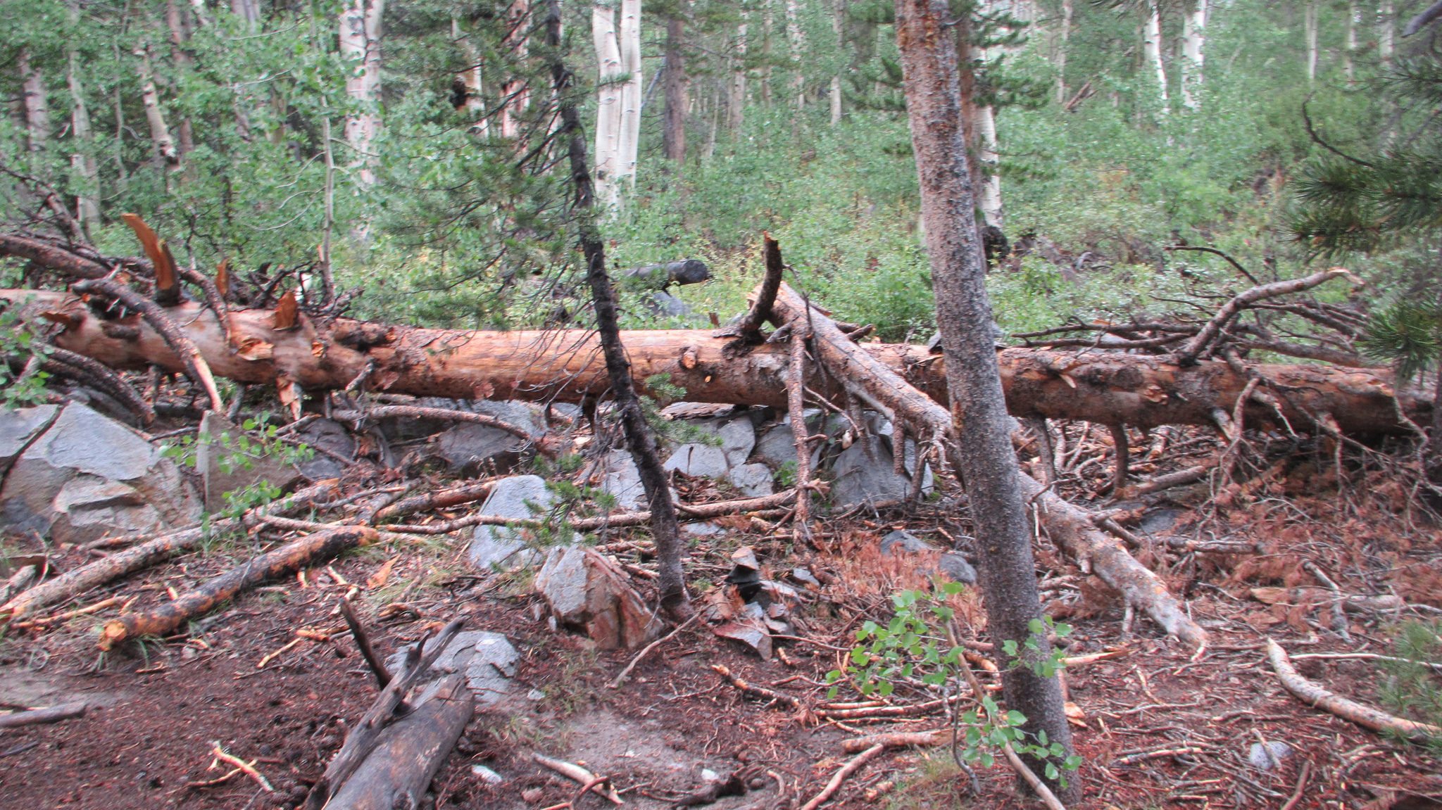
We packed up and started to hike out. The mist in the forest set a dreamlike tone for the hike. We found some gooseberries along the way, and my son and I stopped for a quick snack. We were eager to follow the trail past where we rejoined it the day before, and figure out where we went wrong. It was pretty obvious when we got there. A big tree had fallen across the trail, and there was a lot of debris that kept the upper section hidden in the trees. We even saw that someone had setup some rock cairns on the fallen tree, but they were easy to miss…as we obviously did. We tried to make some more trail markers before leaving, but I’m not sure how much luck the next hiker will have.
Before we made it out, the rain started up again. With all the steep downhill though, we made it out to the trailhead pretty quickly, and nobody got too wet. It felt too early getting back to the car before noon, so we decided to do a little exploring on the drive home. We stopped at Travertine Hot Springs in Bridgeport, but it was full. We drove across the valley to Buckeye Canyon Hot Springs, but it too was at capacity. Looked like everyone else had the same idea on this drizzly day! To finish off the trip right, we made our usual stop at Walker Burger in Walker, CA. Its backyard style dining area is perfect for grubby backpackers and dogs, and the food tastes great after a night in the mountains.
While we had a great time on this hike, the rain made it feel rushed compared to most of our other trips. I was really looking forward to the climb up to Kidney Lake, but we didn’t get much exploring in besides the trail. The trail itself is in poor condition, and the steep road climb is not as fun as many other trails we’ve hiked. One of the neat things about this hike, though, was all the transitions. High sagebrush desert, to pinyon pines, to mixed forest with aspens, and finally becoming alpine, all in just a few miles. Overall this area definitely warrants another trip in for more exploration. It’s high on scenery and solitude while being close to services and many other things to do. We’ll definitely be back.
